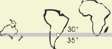
The Republic of Uruguay lies between 30° and 35° South latitude, on the eastern seacoast of the South American continent.The landscape features lagoons and beaches along the coastline, and hills rising above gently rolling plains broken by streams and rivers.
The climate of Uruguay is temperate and the rainfall pattern is evenly distributed throughout the year. There is a notable difference between the daytime and night temperatures, that improves the ripening of the grapes during the harvest season.
Most of the country's 3 million inhabitants are of European origin and are spread over a surface of 176,215 square kilometers. Approximately half of the population lives in the capital, Montevideo. The official language is Spanish.
GEOGRAPHICAL SITUATION
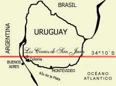
Placed between San Juan river and de la Plata river, Depto. de Colonia - Uruguay.
30 km far from Colonia del Sacramento city (declared part of the World Heritage List)
In front of Buenos Aires, Argentinian Republic capital city.
210 km from Montevideo, capital of Uruguay. |
|
ACCESS
The main entrance to the Estancia Los Cerros de San Juan lies in the Route 21, km 213,5.
It can also be rached by ferry from the Plata and San Juan rivers.
CLIMATE
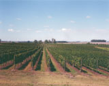
The Cerros de San Juan region, spanning rolling hills and bordering the San Juan river and the River Plate, features sunny summers with cool nights, creating a wide variation in temperatures (up to 18ºC). |
|
SOIL
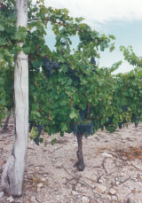
The suitability of the soils for wine growing in the Cerros de San Juan region is due to the rocky nature of the mountains which border the region , with excellent drainage.
The red and white grapes grow in pebbly soils, reaching a perfect ripeness in harmony with the climate. |